
Mézilhac is a commune in the south of the department, about twenty kilometres north of Aubenas. The Col de Mézilhac (1,119 metres above sea level) and the village mark the junction between the Boutières (north), the Cévennes of the Ardèche (south) and the Ardèche plateau (west).

Mézilhac: Map, key figures, services
- A village in the Aubenas Basin Community of Communes
- 92 inhabitants (municipal population)
- 26.66 km², giving a population density of 3.5 inhabitants per km²
- Altitude from 717 to 1,445 metres
- Postcode: 07530 / INSEE code: 07158
Services, tourism
- Town hall website
- Hotels and accommodation nearby: Selection, online booking
- Access by public transport
- Tourist Information Centre for the municipality
- Introduction to the Aubenas Basin Community of Communes
Weather
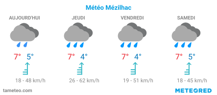
See also: Weather forecasts for the Ardèche department and by town.
Webzine+Ardèche
- Introduction to the town, Wikipedia
- INSEE statistics for the municipality
- Hiking in the Ardèche and IGN maps
- Maps and key data for the 335 local authorities in the department
- Urban areas and communities of municipalities in Ardèche (EPCI)